Creating “Fixed” GNSS Satellites
Technical & Application Notes
Question: In order to test a GNSSGlobal navigation satellite system (GNSS): A general term describing any satellite constellation that provides positioning, navigation, and timing (PNT) services on a global or regional basis. See also receiver, can I make satellites (whether GPSGlobal Positioning System is a navigation satellite system. See also, GALILEO, BEIDOU or GLONASS) fixed?
Answer: Yes
Why simulate a static GNSS space vehicle?
Depending on their application, users can have several objectives when simulating a static or fixed GNSS space vehicle:
- Doppler zero tracking cases
- Code and carrier tracking loops design and test processes
- CRPA system type calibration
- DOP measurement and adjustment
- Kalman filtering design
The ability to simulate fixed or static satellites is a helpful tool for receiver manufacturers or advanced developers who have access to advanced features of their GNSS system for specific tests like those listed above. GNSS receivers are normally designed to track GNSS constellations with “moving satellites” so they will typically be unable to achieve a complete solution when the constellation is considered “fixed” within the simulator. Mastering the design is critical for such simulation applications.
This technical note explains how to designate a few (5-12+) GPS, GALILEO, BEIDOU or GLONASS SVIDs (Space Vehicle IDs) as “fixed”. This can be accomplished with either a GSG-7 or GSG-8 which are powered by the Skydel Software Engine.
Creating Fixed Satellites Using Skydel
GSG-7 is the newest positioning, navigation, and timing test solution offered through Orolia’s GSGA GNSS Signal Generator is a device that is able to create simulated satellite signals and generate real RF signals by first producing I/Q data and calculating the orbits of satellites at a user-defined time, location and trajectory. family of simulators. Built using a smaller form factor than the GSG-8, GSG-7 was developed to deliver the highest standard of Global Navigation Satellite System (GNSS) signal testing and sensor simulation performance.
Both use the Skydel Software Engine, which is able to “fix” a satellite’s position during a simulation.
Two different modes can be used in order to “fix”a satellite in the sky with Skydel. You can use either Skydel’s UI or API:
- In GPS -> Orbits, uncheck the box “Update sat. position during simulation”
- Or, in GPS -> Orbits, check the box “Geostationary” to change the distance of the satellite to the earth
Of course, both options are not realistic, but it allows a constant pseudorange value for users to perform specific measurements.
Option 1: Stop updating satellite position during simulation
Method: For each constellation, the user “forces” each satellite to work without updating its position. In the Orbit menu, disable the “Update sat. position during simulation” field to force this feature to be inactive.
- GPS -> Orbits -> Update sat. position during simulation

Note: This option is equivalent to providing a fixed Pseudorange. However, the ephemeris is still updated, so receivers under test may refuse to maintain their navigation solution for a proper PVT as they find incoherence between sat distance and navigation data. This feature is helpful for receiver manufacturers or advanced developers who have access to advanced features of their GNSS system for specific tests. This option has the effect of removing the Doppler shift on the satellite and suspending the satellite in a fixed location relative to the Earth.
Example:
When satellites are updated (normal use case): You can see here all satellites have moved (GPS and GALILEO) – (examples following arrows for GPS SV 1, 21 and GAL SV 12 and 24)
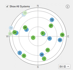
View at 12h00
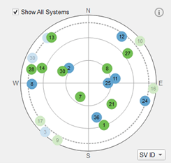
View at 12h30
After unselecting the field “Update sat. position during simulation” to force this feature inactive:
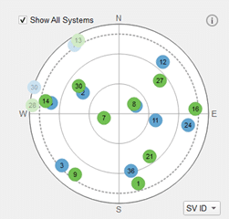
View at 12h00
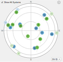
View at 12h30
In this example, we only unselected GALILEO satellites and launched the simulation. The GPS satellites moved (green plots), but GALILEO’s kept the same position (blue ones).
Option 2: Setting target satellites as Geostationary:
- GPS -> Orbits -> Geostationary
Method: For each constellation, the user forces the satellite to work in geostationary mode; from the Orbit menu, leave the “Update sat. position during simulation” active, but Enable Geostationary mode
Users will need to provide longitude in the following field for each satellite selected as geostationary.

You can find more information in the User Manual, in chapter 8.7.4.6.1.
Note: In geostationary mode, all satellites will be placed at the same latitude and longitude by default. You can set the first satellite at the exact longitude where the vehicle will be simulated and set other satellites at different offsets of longitude to avoid all satellites being placed at the same position. This will allow you to adjust position accuracy by changing the configuration (which will impact the DOP value) during your tests.
Example: Starting from a scenario with 6 GPS + 6 GALILEO satellites.
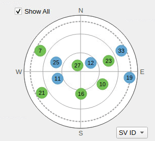
We changed only GPS satellites to Geostationary (GALILEO satellites remain in normal mode). We changed 5 GPS satellites’ longitude values to distribute the constellation over the sky (see tip above).
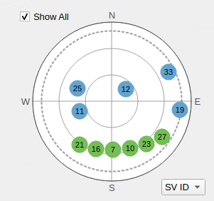
Note: This option does, however, has the following side effects to consider:
- Satellite distance will be GEOGeostationary Earth Orbit is a circular orbit trajectory that is geosynchronous with Earth's rotational movement. Because it matches Earth's rotation, a satellite in a geostationary orbit appears to be stationary to an observer on the ground. (36,000km) and not that of GNSS constellations (around 20,000 km). So, power levels need to be adjusted in consequence. (e.: disable straight signal model, antenna patterns etc.)
- All satellites will be at the same place on the equator. It is possible to change the longitude through the menu, but many receivers will have difficulty finalizing PVT due to the bad DOP value caused by the satellite configuration, as mentioned in the Tip above).
- It is possible to combine fixed satellites + some other moving satellites elsewhere (be aware that they will start to move as well).
Conclusion: This feature offers many advantages and can be easily configured on SKYDEL simulators, but is recommended for receiver manufacturers or advanced developers who have access to advanced features of their GNSS system.
Setting a GNSS satellite as “fixed” can be extremely useful for receiver manufacturers or advanced developers that have deep access to advanced features of their GNSS system. Of course, simulating such a scenario is not only an unrealistic GNSS movement, but contrary to the primary purpose of a GNSS simulator. Skydel’s flexibility, however allows this ability that is sometimes requested by operators who need fixed satellite simulations to ensure they keep the same position during a test or simulation.
Alternatively, operators can also combine some “fixed” satellites with moving satellites.
Whichever option is chosen, Skydel provides an innovative and flexible environment to create these scenarios – both real and unreal.
